Number of Pictures on Student Websites Assignment
Climate/nature- 12
Niagara falls/bodies of water- 11
Currency/stamps- 3
Natural Resources (coal, oil, metal mining, hydroelectricity)- 16
Plants/trees- 4
Powerful People- 15
Buildings- 8
Maple leaf- 11
War- 4
Thematic maps- 26
Government/economy- 21
Activities- 13
Imports/Exports- 5
Food- 6
Holidays- 4
Mountains- 7
Clothing- 1
Language/religion- 4
Jobs- 1
Canada Collage
Thematic Maps

This map shows the population density of Canada, most of the people live just north of the U.S. Canada border.
|

This map shows the climate zones of Canada. Most people live in the warmest parts of Canada- the south.
|

This map shows the different regions of vegetation. Most people live in the mixed forest region, the parkland region, and the grassland region.
|
Physical Geography, Climate, and Nature
This picture shows arctic, Northern Canada. It is very cold here.

This picture shows the Prairie region of Canada. It is mostly grassland, parkland, and boreal forest. More people live here than on the tundra because it is warmer.

This is a map showing the average precipitation in Canada. Most people live where there is little to medium amounts of rain.
|
Economics
This picture shows trees in southern Canada that have been cut down to export to other countries. Many people have jobs cutting down trees.

This map shows the different types of mines and where they are located in Canada. Canada mines different types of metals to export. Mining is a popular job in Canada

This picture shows an oil rig in Canada. Oil wells are common in Alberta, and oil is shipped exported to other countries. Drilling for oil is a common occupation in Canada.
|
Government
This chart shows the different types of government in Canada and their similarities/differences. Some laws are the same, but not all.

This flow chart shows the different branches of government and what is included in them. Canada and the U.S. have the same branches of government.

Even though Canada is one country, provinces and territories come up with some of their own laws and use different languages. Laws differ depending on where in Canada you live.
|
History
What is now Canada was discovered in 1534 by Jacques Cartier. Canada has changed a lot since it was first discovered.
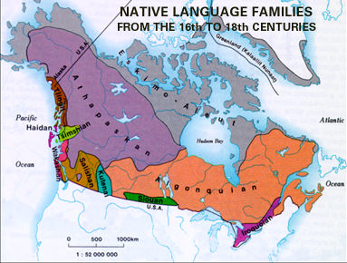
This picture shows the different groups of people living in Canada from the 16th-18th centuries. There were many different groups.

This map shows the different languages that are spoken today in Canada. The different groups of people from early times have stuck to the same language that they have always used.
|
Human Geography
One thing Canadians we eat that we don't is horse mean. This is the only major difference in food between Canada and the U.S. Most Americans don't agree with this action.

Many Canadians like to play hockey. It is more popular in Canada than it is in the U.S.

Canadian Independence Day is on July 1st. This is one many cultural differences between the U.S. and Canada.
|
